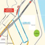
The tsunami evacuation zones for Thorndon/Pipitea we used in 2014/15 were based a regional modelling project undertaken in 2008. The inundation estimates were based on an empirical ‘rule-based’ tsunami height attenuation modelling technique.
However the latest definition for the tsunami evacuation zones are a little different. These have been calculated using more detailed hydrodynamic inundation modelling of Wellington Harbour undertaken in 2015.
For more information visit www.arcgis.com
The consequence is that a significant number residences, and three schools, no longer fall into a tsunami evacuation zone.
The greatest changes were for the yellow zone which is primarily for self-evacuation in the event of a strongly-felt or long-duration earthquake, or when a forecast of a distant-source tsunami of above a specific threat level is issued.
A lot more information can be discovered using the region’s online mapping resources at
http://mapping.gw.govt.nz/GW/GWpublicMap_Mobile/
Don’t wait until it’s too late! Find your home and workplace now – develop your evacuation plan and set your household/whanau/workplace meeting point.


